Фортеця Харків: Нове місто на сучасній карті

Озвучено за допомогою ШІ (Google Cloud).
Текст перекладу
Kharkiv Fortress: The "New Town" on the Modern Map
The term "New Town" (Nove Misto) in connection with the history of Kharkiv appeared relatively recently—after 1917. Before that, not a single researcher mentioned it in their works. To this day, this topic remains little-known and sparsely investigated. This article is the first to describe both the history of the emergence of the New Town and the layout of its fortifications relative to modern Kharkiv streets.
The Kharkiv Fortress met the end of the 17th century in a rather sad state. The old fortifications were increasingly falling into decay. The roofs on many towers had collapsed. The moats, unreinforced with logs, were crumbling. The Small Town (Male Misto—a small wooden fort / ostrozhok appended to the south of the citadel), which constantly suffered from seasonal flooding, was the most problematic sector. The citadel itself remained more or less intact, although troubles with its timber walls and towers arose there from time to time as well.
To the north and northeast of the citadel, the fortress was overgrown with Cossack homesteads, whose sole defense was the old outer rampart, which had not been updated since its initial construction.
Meanwhile, the Tsardom of Muscovy was waging war against the Ottoman Empire. In 1695–1696, Tsar Peter I launched military campaigns against Azov, mobilizing all available resources for combat operations. During this time, Kharkiv emerged as an additional staging and supply hub for providing ammunition, provisions, and forage to the Muscovite armies.
It was then that the son-in-law of Colonel Hryhoriy Donets (Zakharzhevsky), voivode and stolnik Semen Durnovo, returned to the city. He evidently carried orders to fortify the Kharkiv Fortress by surrounding the most vulnerable sector with new timber walls and moats. This concerned the area north of the main citadel, but the new fortification lines were designed to encompass additional territories to the east and west as well.
The task was formidable, requiring both standing servicemen and a vast quantity of timber, which had to be harvested and hauled into the city from the surrounding wilderness. An additional Muscovite garrison reached Kharkiv only in 1698, and physical work on constructing the new fortification perimeter commenced in the spring of 1699. Most likely, the construction was catalyzed by news of the Crimean Khan, who was advancing toward Sloboda Ukraine with an army of 30,000 horsemen. To be sure, he never reached Kharkiv proper; he only advanced as far as the Perekop fortress near modern-day Valky, which he burned before retreating.
That same year, 1699, construction began on the outer suburb (vorstadt), which encompassed extensive areas filled with existing Cossack settlements. This expanded fortified perimeter received the name New Town (Nove Misto).
In total, 17 new defensive towers were erected, including six gate towers (proyizni bashty). Their height ranged from seven to eight fathoms (15 to 17 meters), depending on whether they were topped with a covered watch-cabin. The city's wooden curtain walls (horodovi stiny), constructed from solid oak and featuring overhanging combat galleries (oblamy), reached a height of three fathoms (approximately 6.4 meters). These were three-sided timber crib structures (kliti) filled with tightly packed earth on the inside, with heavy rolling logs (kotky) mounted along the top parapets to hurl down at attackers. The total perimeter length of the New Town's fortifications spanned 980 fathoms (roughly 2,088 meters).
The construction of the New Town was critically important for the garrison of the Kharkiv Fortress for several strategic reasons. First and foremost, it enabled the construction of a new powder magazine, as there was simply no physical space left inside the central citadel. It was engineered concurrently with the walls and towers, though military gunpowder stockpiles began arriving only in 1701.
Additionally, the central government ordered the establishment of a major new salt depot to store salt transported from the Tor Salt Lakes (modern-day Sloviansk). It was decided to concentrate massive strategic reserves of salt precisely within Kharkiv. Naturally, both facilities were of paramount strategic importance and required the absolute protection of fortress walls.
The fortification lines of the New Town originated at the New Trinity Gate Tower (Nova Troitska) of the Small Town, which was situated at the modern intersection of Kooperatyvna Street and Korolenko Lane (it should be noted that all geographic references herein utilize contemporary street names). The wooden curtain walls extended for 100 fathoms (about 213 meters) to the intersection with Heroes of Kharkiv Avenue and Slyusarnyi Lane, where the new Chuhuiv Gate Tower (Chuhuivska) was raised. This specific sector was additionally reinforced with an exterior moat, which was continued past the next blind (non-gate) tower for another 13 fathoms (about 28 meters).
Further along, for a span of 223 fathoms (roughly 475 meters), neither walls nor moats were built. This gap existed because the terrain was defined by natural oxbow lakes of the Kharkiv River and marshy wetlands, through which the townspeople had built causeways and roads over previous decades. Thus, for defense along this sector, it was sufficient to simply block these thoroughfares with gate towers, erecting anti-cavalry wooden spikes (nadolby) and turnstiles (vertlyuhy) in the marshy gaps between them.
The first gate tower along this line, the Saltivska Tower, was erected 90 fathoms (about 192 meters) from the blind tower, near the modern intersection of Slyusarnyi Lane and Mykolaivska Street. The second gate tower—the New St. Nicholas Gate Tower (Nova Mykolaivska)—was positioned 133 fathoms (about 283 meters) further along. From there, timber curtain walls resumed, running for 31 fathoms (about 66 meters) to a corner tower at Teatralnyi Lane.
The northern curtain walls of the New Town stretched along Teatralnyi Lane. They utilized the natural topography, with both the walls and towers constructed along the high crest of a natural ravine. At a distance of 46 fathoms (98 meters) from the corner tower stood a blind tower; 42 fathoms (roughly 89.5 meters) past that stood a second blind tower; and another 41 fathoms (about 87 meters) further was the New Moscow Gate Tower (Nova Moskovska), positioned at the corner of modern Hryhoriy Skovoroda Street and Poetry Square.
Continuing forward, the curtain walls, reinforced by a moat, ran along modern Teatralna Square. A blind tower stood at a distance of 53 fathoms (about 113 meters), and after another 50 fathoms (about 106.5 meters), the gate-fitted New Derkachivska Tower was raised on Sumska Street.
From the New Derkachivska Tower, the wall and moat continued along Nekrasov Lane, where a blind tower sat at 32 fathoms (about 68 meters), before reaching Klasychnyi Lane (which at that time was a steep natural gully serving as an auxiliary defensive barrier). At a distance of 80 fathoms (roughly 170 meters) stood another blind tower (at the sharp bend of Klasychnyi Lane), and 50 fathoms (about 106 meters) further, midway down the same lane, sat the Zolochiv Gate Tower (Zolochivska). Just 10 fathoms (about 21.3 meters) beyond it, at the intersection of Klasychnyi Lane and Klochkivska Street, stood the corner blind Lopan Tower, which marked the beginning of the New Town's western wall line.
These western timber walls extended along Klochkivska Street all the way to the main citadel's Lopan Gate Tower, located on Sobornyi Descent. Along this stretch, 50 fathoms (about 106.5 meters) from the corner tower—roughly midway down Bursatskyi Descent—a narrow pedestrian sally port (fortka) was built into the timber wall. Mounted cavalry or carts could not pass through this narrow gate.
At a distance of 46 fathoms (about 98 meters) from the sally port stood the blind Middle Lopan Tower. Another 90 fathoms (about 192 meters) past it, a second pedestrian sally port was pierced through the timber wall. Eight fathoms (about 17 meters) beyond this port stood the final blind tower of the New Town, the site of which corresponds to modern Pokrovskyi Park. From this tower to the main citadel's Lopan Gate Tower was a final distance of 30 fathoms (about 64 meters).
The New Town was documented for the first time in the official 1700 Smetna Knyha (Estimate Book) of the Kharkiv Fortress, compiled during the governorship of Ivan Korobyin. Despite a few minor clerical errors in the survey, this source provides an invaluable overview of the radical transformations in the city's fortification system. In subsequent years, the New Town's defense lines would be reinforced with earthen redoubts, deeper moats, and higher ramparts, but their primary architectural footprint was established in 1699. By the early 18th century, all gate towers were heavily reinforced with artillery cannons.
Within this vast new outer suburb, the state secured not only its vital reserves of gunpowder and salt and private Cossack homesteads, but also two major churches. Specifically, the St. Nicholas Church was enclosed; its old palisade walls were removed, leaving a standard wooden fence. The second house of worship was the private estate Church of the Intercession, absorbed alongside the residential compound of Kharkiv Cossack Colonel Fedir Donets (Zakharzhevsky). Furthermore, the regimental chancellery—which had previously operated outside the main citadel walls—was brought under the direct protection of the new fortification perimeter.
The irregular, jagged boundary fences of the Cossack homesteads inside the new perimeter were systematically realigned to form orderly streets. In essence, urban development transitioned toward planned grid layouts—marking a direct milestone in Kharkiv's evolution from a purely military frontier fortress into a true, functional city.
In 1709, by direct decree of Tsar Peter I, the main citadel was expanded northward, drawing its inner walls closer to the New Town's perimeter. During the catastrophic urban fire of May 1733, a vast portion of the New Town's wooden walls burned to the ground. The timber walls were never rebuilt; instead, the remaining towers were reinforced with earthen redoubts, and the moats and ramparts were significantly enlarged.
Traces of the New Town's wooden curtain walls can still be discerned on the 1742 master plan of Kharkiv drafted by Engineer-Captain Ivan Satsyperov. Minor structural repairs were executed as late as 1748, but the decaying timber walls were subsequently ordered to be dismantled due to rot. By 1759, all wooden fortification structures belonging to the New Town of the Kharkiv Fortress had permanently ceased to exist.
“Kharkiv Fortress” is an ongoing historical series by Andriy Paramonov, a dedicated researcher of Sloboda Ukraine's history. Read the author’s full column on MediaPort.
Термін «Нове місто» у прив’язці до історії Харкова з’явився відносно недавно — після 1917 року. До того його не згадував у своїх працях жоден дослідник. І дотепер ця тема залишається маловідомою і малодослідженою. Цей матеріал — перший, що описує як історію виникнення Нового міста, так і розташування його укріплень відносно сучасних харківських вулиць.
Кінець XVII століття Харківська фортеця зустрічала доволі сумно. Старі укріплення все більш занепадали. Дахи на багатьох баштах обвалились. Рови, не укріплені колодами, обсипались. Мале місто (острожок, добудований з півдня цитаделі), яке весь час потерпало від повеней, було найбільш проблемним. Сама цитадель залишалася більш-менш цілою, хоча і там час від часу виникали негаразди з дерев’яними стінами і баштами. З півночі і північного сходу від цитаделі фортеця обростала козацькими дворами, єдиним укріпленням для яких слугував старий зовнішній вал, що не оновлювався від початку свого існування.
Між тим Московське царство вело війну з Османською імперією. У 1695-1696 роках цар Пьотр Алєксєєвіч здійснив походи під Азов, залучивши для бойових дій всі можливі ресурси. В цей час Харків постає додатковим перевалочним центром із забезпечення амуніцією, продовольством і фуражем московських армій. Саме тоді до міста повертається зять полковника Григорія Донця (Захаржевського) воєвода і стольник Семен Дурново, який вочевидь мав наказ укріпити Харківську фортецю, оточивши стінами та ровами найбільш небезпечну ділянку.
Йшлося про території на півночі фортеці, але при цьому нові укріплення мали охопити додаткові території зі сходу і заходу. Завдання було доволі складним, оскільки його виконання потребувало і служилих людей, і значної кількості лісу, який треба було доставляти в місто з навколишніх територій. Додатковий московський гарнізон дістався до Харкова тільки у 1698 році, а роботи з формування нових укріплень розпочалися лише навесні 1699 року. Ймовірно, їх простимулював кримський хан, який сунув на Слобожанщину з військом у 30 тисяч вершників. Щоправда, до Харкова він не дістався — дійшов лише до фортеці Перекоп неподалік сучасних Валок, яку спалив і тим обмежився.
Тоді ж, 1699 року, почалося і будівництво форштадта, який охоплював значні території з козацькими поселеннями. Він і отримав назву Нове місто. Загалом було зведено 17 нових башт, у тому числі шість проїзних. Їхня висота становила від семи до восьми сажнів (15-17 м) залежно від наявності дозорної кліті. Городові стіни з обламами, побудовані з дубу, сягали трьох сажнів (близько 6,4 м) заввишки. Це були кліті на три стіни, засипані землею всередині. Нагорі були встановлені котки. Загальна довжина укріплень Нового міста складала 980 сажнів (близько 2088 м).
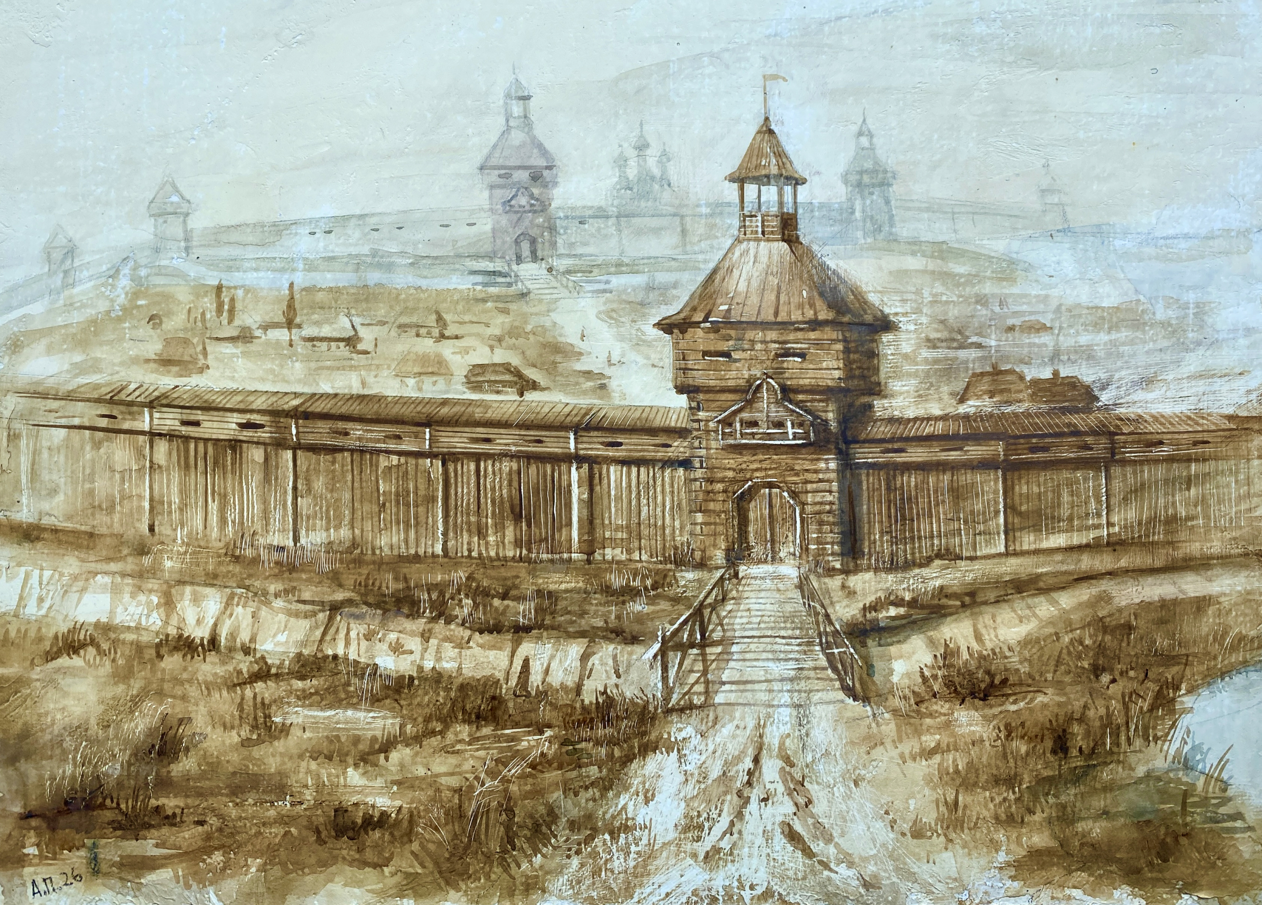
Будівництво Нового міста було важливим для московського гарнізону Харківської фортеці з декількох причин. В першу чергу це дозволило побудувати новий пороховий льох, для якого в цитаделі вже просто не було місця. Його облаштовували одночасно із стінами і баштами, але запаси пороху почали надходити лише у 1701 році. Окрім цього, московський уряд повелів зробити і новий соляний магазин, куди доставляли сіль з Торських озер (сучасний Слов’янськ). Саме в Харкові було вирішено створити великі або значні запаси солі. Зрозуміло, що обидва об’єкти мали стратегічне значення, тож потребували захисту фортечних стін.
Укріплення Нового міста починалися з Нової Троїцької проїзної башти Малого міста, яка розташовувалась на розі Кооперативної вулиці і провулку Короленка (одразу зазначу, що тут і далі вказані сучасні назви вулиць, провулків та інших топонімів). Городові стіни були прокладені на 100 сажнів (близько 213 м) до перехрестя з проспектом Героїв Харкова і Слюсарним провулком, де поставили нову Чугуївську проїзну башту. Ця ділянка була додатково укріплена ровом, який продовжили до наступної глухої башти ще на 13 сажнів (близько 28 м). Далі протягом 223 сажнів (близько 475 м) ані стін, ані ровів не будували, оскільки на цій ділянці існували стариці річки Харків, озера з заболоченою навкруги територією, між якими харківці у попередні десятиліття проклали дороги. Отже тут для укріплення було достатньо перекрити ці дороги проїзними баштами, а між ними поставити лише надовби і вертлюги. Першу проїзну Салтівську башту встановили через 90 сажнів (близько 192 м) від глухої, близько перехрестя сучасного Слюсарного провулку і Миколаївської вулиці. Другу проїзну башту — Нову Миколаївську — через 133 сажні (близько 283 м). А від неї вже знову йшли городові стіни на 31 сажню (близько 66 м) до кутової башти на Театральному провулку.
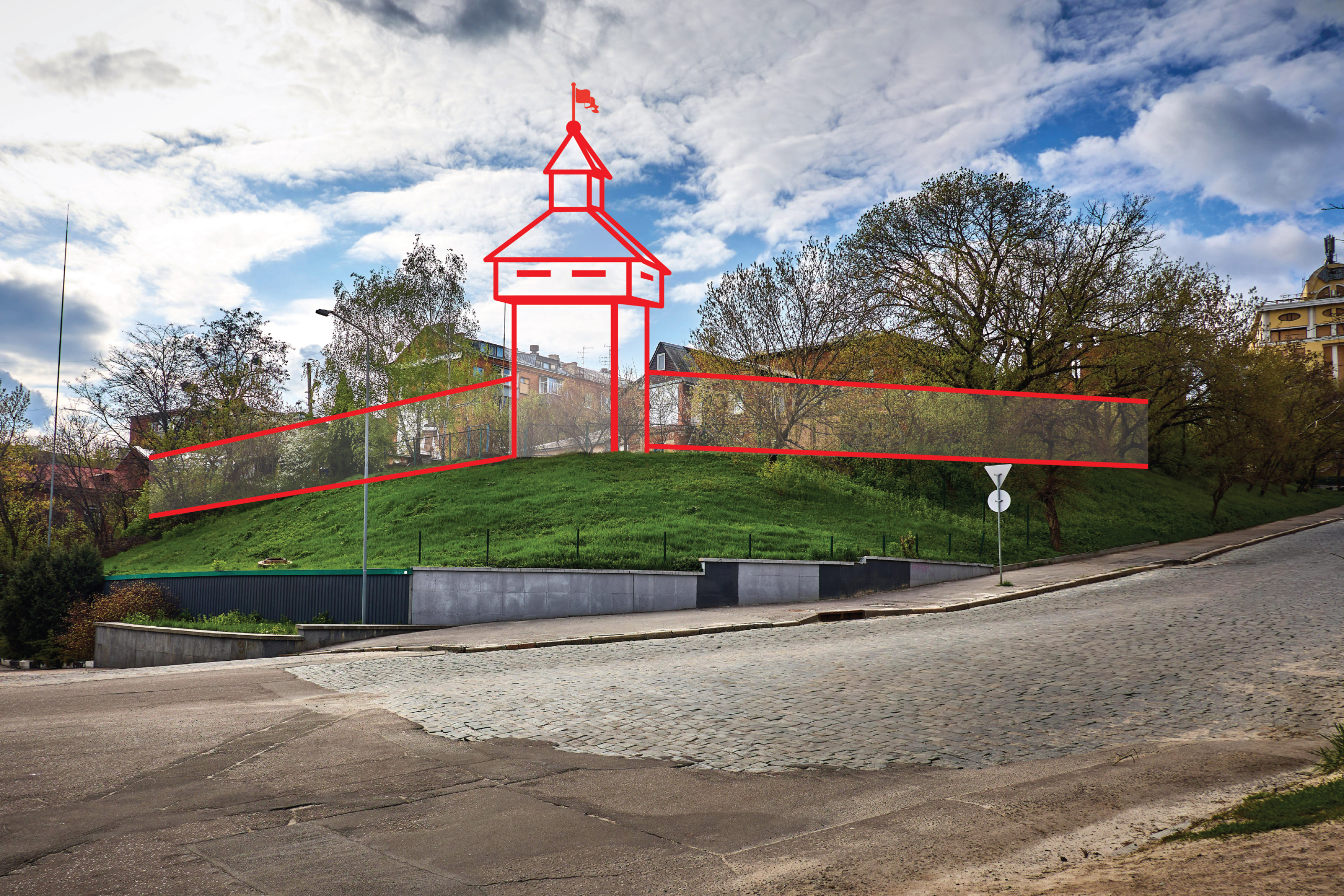
Вздовж Театрального провулку тягнулися північні стіни Нового міста. Вони спирались на рельєф місцевості, і їх, і башти тут побудували понад яром. Через 46 сажнів (98 м) від кутової башти була поставлена одна глуха башта, через 42 сажні (близько 89,5 м) від тієї — друга, а ще через 41 сажню (близько 87 м) — Нова Московська проїзна башта (вона стояла на розі вулиці Григорія Сковороди і площі Поезії). Далі городові стіни посилені ровом тягнулися вздовж Театральній площі. Через 53 сажні (близько 113 м) стояла глуха башта, ще через 50 сажнів (близько 106,5 м) на Сумській вулиці стояла проїзна Нова Деркачівська башта.
Від Нової Деркачівської башти городові стіни, посилені ровом йшли по провулку Некрасова, де через 32 сажні (близько 68 м) стояла глуха башта і виходили на Класичний провулок (тоді це був природній ярок, який слугував додатковим укріпленням). Через 80 сажнів (близько 170 м) стояла ще одна глуха башта (на місці залому по Класичному провулку), а через 50 сажнів (близько 106 м), в середині того ж провулку, — проїзна Золочівська башта. Через 10 сажнів (близько 21,3 м) від неї, на перехресті Класичного провулку і Клочківської вулиці, стояла кутова глуха Лопанська башта, від якої починались західні городові стіни Нового міста.
Вони тягнулися вздовж Клочківської вулиці до Лопанської проїзної башти цитаделі, що стояла на Соборному узвозі. Вздовж цих стін через 50 сажнів (близько 106,5 м) від кутової башти, десь посередині Бурсацького узвозу була зроблена так звана фортка, тобто ворота для проходу піших людей. Кіннотник чи віз проїхати через «фортку» не могли. Через 46 сажнів (близько 98 м) від «фортки» стояла глуха середня Лопанська башта. Через 90 сажнів (близько 192 м) від башти у стінах зробили ще одну «фортку». Через вісім сажнів (близько 17 м) від неї стояла остання глуха башта Нового міста, орієнтиром для її розташування можна вважати Покровський сквер. Від неї до Лопанської проїзної башти цитаделі було 30 сажнів (близько 64 м).
Нове місто вперше було описане в «Сметной» книзі на Харківську фортецю 1700 року за часів воєводства Івана Короб’їна.
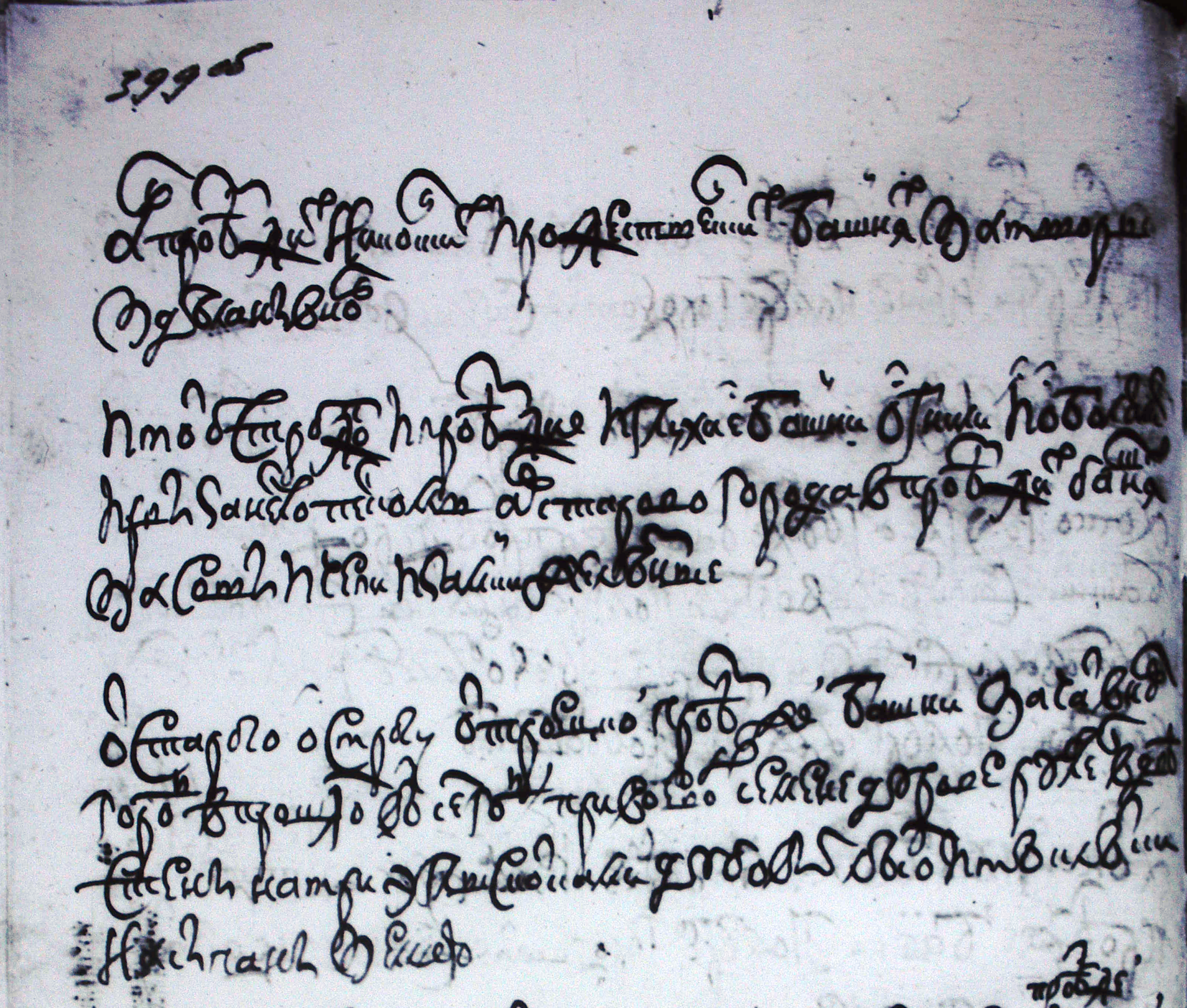
Попри деякі несуттєві помилки в описі, саме це джерело дає загальне уявлення про значні переміни в фортифікаційних спорудах. Надалі укріплення Нового міста посилюватимуться редутами, ровами і валами, але їхню основу було закладено саме 1699 року. На початку XVIII століття проїзні башти були посилені гарматами.
Усередині нового форштадту опинились не тільки стратегічні запаси пороху, солі та козацькі подвір’я, але і два храми. Зокрема Миколаївська церква, острожні стіни навколо якої прибрали, залишивши лише звичайну огорожу. Другою церквою стала домова Покровська, яка увійшла разом із двором Харківського полковника Федора Донця (Захаржевського). Крім того, під захистом фортечних стін опинилась полкова канцелярія, яка до цього розташовувалася поза цитаделлю. Криві і косі огорожі козацьких дворів почали випрямляти і формувати вулиці в середині форштадту, тобто справа йшла до планової забудови, а це вже прямий шлях до Харкова не як фортеці, а як міста.
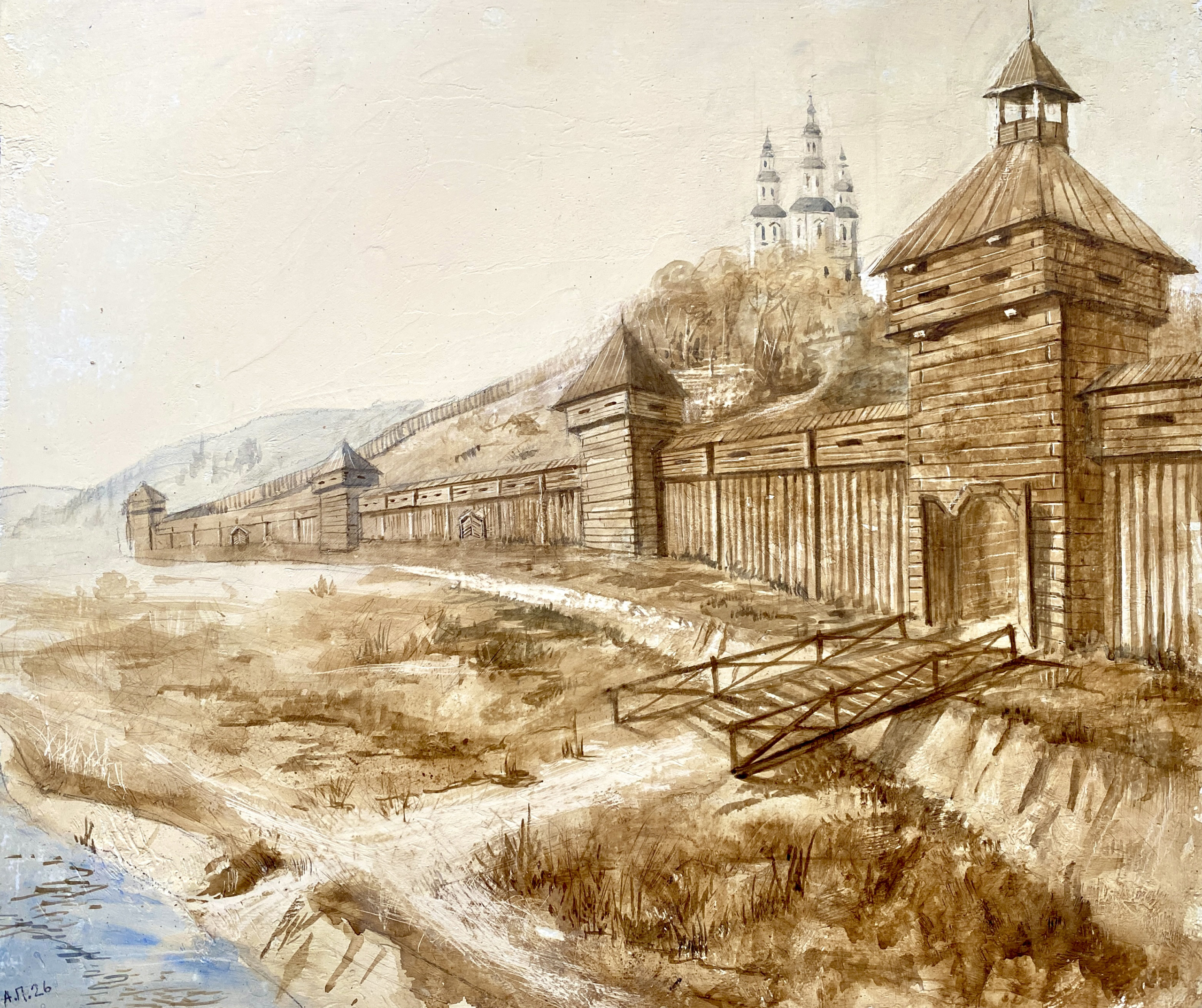
У 1709 році за наказом московського царя Петра була розширена на північ і цитадель фортеці, і її стіни підтягнули ближче до форштадту Нового міста. Під час пожежі травня 1733 року значна частина стін Нового міста згоріла. Їх вже не відновлювали, натомість башти посилили земляними редутами, а рови та вали — збільшили. Частину городових стін Нового міста ще можна побачити на плані Харкова 1742 року інженер-капітана Івана Саципєрова. У 1748 році їх ще частково ремонтували, але пізніше вирішили розібрати через трухлявість. На 1759 рік всі дерев’яні укріплення Нового міста Харківської фортеці перестали існувати.
Дослідник історії Слобідської України Андрій Парамонов — автор циклу матеріалів «Фортеця Харків». Читайте колонку Андрія Парамонова на MediaPort.