Фортеця Харків: недовгий вік острожка на Ржавому колодязі та його довговічна «зміна»

Озвучено за допомогою ШІ (Google Cloud).
Текст перекладу
Kharkiv Fortress: The Short Life of the Watch-Post on the Rzhavyi Well and Its Long-Lasting "Successor"
A small fortified watch-post (ostrozhok) on the Rzhavyi Well, located some fifteen kilometers from Kharkiv, was constructed for security reasons during the formative years of the main fortress. Despite its brief lifespan, it repeatedly thwarted raids by Tatar detachments driving toward Kharkiv. Over time, a small homestead (khutir) emerged near the abandoned fortification, eventually evolving into a village that still exists today, albeit under a different name. How did this watch-post change during its short existence, what made the adjacent village famous, and what role did Donets-Zakharzhevsky play in its story?
From the very tenure of Kharkiv's first military governor (voivode), Voin Selifontov, the vulnerable sector on the distant approaches to the main fortress was a constant source of anxiety. The primary concern was the strategic highway running from Belgorod through Kharkiv to the Mozhesky stationary watch-post. Constructed in 1646, the Mozhesky fort stood on the eastern flank of the Perekop earthen rampart, near the headwaters of the Mzha River. Initially, the route from Kharkiv followed the right bank of the Lopan River, but by 1658, a new road had been established, cutting through the future villages of Osnova and Udy (also known as Filipove Selo). This trail passed by Grigory Karkach’s apiary, the Rybnyi ravine, and the Zhovtyi burial mound—all three historical landmarks have since vanished from modern maps. From Filipove Selo, the road stretched through dense woodlands to the modern village of Rzhavets, crossing the river of the same name before heading through the Kosmach valley and the modern village of Yakovlivka toward Merefa.
Originally, the Mozhesky fort sat directly on the Muravsky Trail. This corridor was regularly used by both raiding Tatar detachments and the Cossacks of the Poltava Regiment, who frequently marched toward Kharkiv to plunder the Sloboda settlers. In 1665, the Mozhesky fort was relocated to the confluence of the Mzha and Turushka rivers. Prior to this, however, Kharkiv's second military governor was forced to establish two temporary watch-posts, later adding a third, garrisoned by servicemen tasked with delivering early warnings of an imminent enemy assault on the main fortress.
In 1657, the inhabitants of Kharkiv, working in coordination with the garrison of Chuhuyiv, constructed a small wooden fort (ostrozhok) roughly 10 versts (about 17 kilometers) outside Kharkiv. It was positioned atop the highest ridge between the modern settlements of Vysokyi and Babai, immediately adjacent to the Rzhavyi Well River (known today as the Rzhavets River, which flows into the Merefa, a left tributary of the Mzha). Because the Kharkiv governor faced a critical shortage of standing servicemen, a decree issued by the regional governor of Belgorod mandated that the garrison duties at the new outpost be fulfilled by the deti boyarskie (junior military gentry) from Chuhuyiv, who owned lands nearby in the villages of Babai (Arkhangelske) and Zhykhor.
Initially, these men took turns rotating to form the core garrison of the Rzhavyi Well outpost. Later, they were reinforced by mounted servicemen drawn from various fortresses along the Belgorod Defensive Line. The fort was designed as a perfect square, with walls measuring 20 fathoms (about 43 meters) long on each side. The height of the palisade walls stood at 2 fathoms (4.3 meters), excluding the upper overhanging galleries (oblamy) and rolling logs (kotky). Defensive loopholes were arranged across two distinct tiers. Inside the fort, wooden scaffolding platforms were erected along the upper tier to accommodate servicemen armed with heavy matchlock muskets (pishchals).
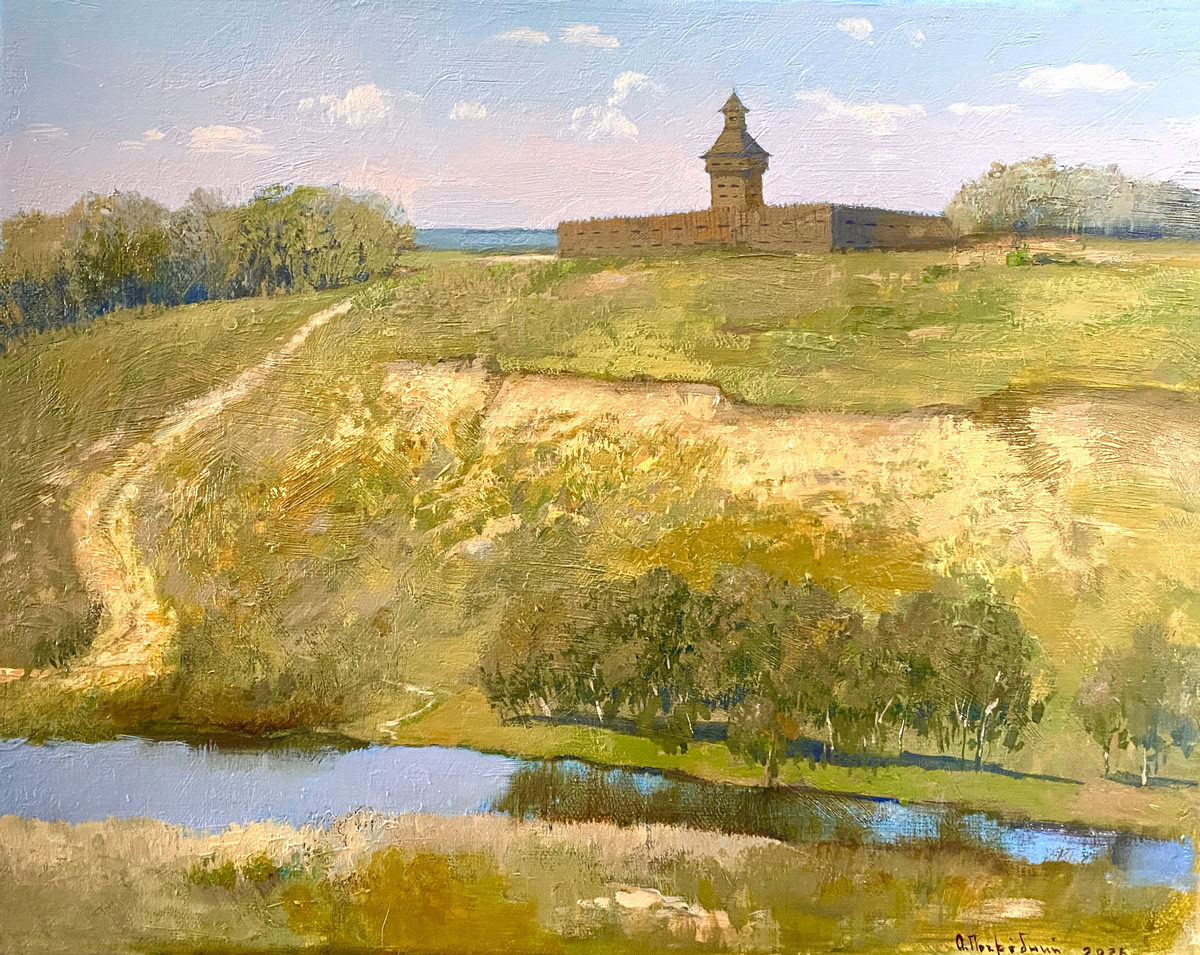
Rising from the center of the fort was a grand defensive tower topped with a covered watch-cabin, soaring to a total height of 8 fathoms (around 17 meters). The first and second tiers of this tower featured loopholes facing all directions for musket defense. The timber-built watch-cabin itself was pierced by four defensive ports, one on each side. Mounted on the tower's second tier was a dedicated signal cannon trained directly toward Kharkiv.
Watchmen pulled continuous day and night shifts atop the tower. “Under penalty of death, they were strictly commanded to vigilantly scout the surrounding wilderness, and upon spotting approaching 'Tatar warriors,' they were to immediately fire a signal shot from the cannon,” wrote the historian Yevgeny Albovsky in his volume, The Kharkiv Cossacks.
Beyond the central tower, the interior of the outpost housed a barracks building for the garrison, a kitchen, and a stable block. Upon detecting an enemy advance, the mounted servicemen would swiftly mount their horses and sprint toward Chuhuyiv, Kharkiv, and further onward to Belgorod to spread the alarm. The fort was constructed directly adjacent to the highway leading to the Mozhesky outpost, and featured no surrounding moats or earthen ramparts. To prevent enemy forces from bypassing the position to the left or right, a 200-fathom (about 430-meter) barrier of felled trees (zasika) was laid out between the dense forest lines. Furthermore, the corridor leading down to the Rzhavets River was blocked by nadolby (anti-cavalry wooden spikes) mounted onto heavy two-legged timber frames (kobyliny) and tightly bound with iron chains.
Throughout 1659, 1661, and 1662, the small garrison at the Rzhavyi Well successfully repelled several minor Tatar raiding groups, holding the perimeter until reinforcements arrived from Kharkiv. However, in 1663, the road connecting Kharkiv to the Mozhesky outpost was permanently blocked by the newly established fortress-town of Merefa. This larger fortification proved far more effective at intercepting enemy columns driving toward Kharkiv. Consequently, the watch-post garrison at the Rzhavyi Well was cut by half.
The final archival record mentioning an active watch-post at the site dates to 1666. By the following year, the fort stood completely abandoned and derelict: "The felled-tree barriers and the anti-cavalry spikes have collapsed and rotted through in many places." The outpost appears for the very last time in the city's annual Smetna Knyha (Estimate Book) of 1669: "And there is no watch-post garrisoned within that fort, for the Merefa sloboda has settled directly along the Muravsky Trail to hold the watch. No individuals of any rank from Kharkiv ever frequent these parts."
Following his election as Colonel of Kharkiv in 1669, Grigory Yerofiyovych Donets-Zakharzhevsky systematically forced out the old Muscovite servicemen who held land titles in Babai and Zhykhor. He rapidly colonized the region with his own Ukrainian Cossack subjects (cherkasy), establishing a network of new agrarian villages. Significantly downstream from the site of the old watch-post, directly along the road leading toward Valky, a small homestead (khutir) emerged named Salomakhivka.
This name endured until at least 1782. At that time, the settlement consisted of 27 households populated by 166 men and 169 women—Cossack tenant subjects belonging to Pyotr Andreyevich Shcherbinin, a close personal friend of the renowned philosopher Hryhoriy Skovoroda. By 1804, however, official government archives register Salomakhivka under the name of Rzhavets village. It sat along the old Valky road, which had been upgraded into a major post-highway connecting to the provincial capital of Ekaterinoslav (modern-day Dnipro).
The developed village featured a country manor built for the landowner Ekaterina, wife of Colonel Andrei Petrovich Shcherbinin, alongside established roadside inns (postoyali dvory) owned by titular counselor Nikolai Kolyadin and ensign Grigory Topchiyev. Ekaterina Shcherbinina operated a lucrative network of 20 saltpeter mounds (burty) near the village, which processed up to 400 poods of pure saltpeter annually for the state's gunpowder manufacturing works. The local serfs paid their landlord a fixed annual cash rent (obrok) of 200 rubles. They were regarded as highly affluent, owning thriving fruit orchards, private bee yards, and commercial fishing rights on their local estate pond.
Throughout the 19th century, the village of Rzhavets fell administratively under the land-grant boundaries of the neighboring village of Berezove, while spiritually it belonged to the parish of the Archangel Michael Church in Babai. Rzhavets entered a period of sharp economic decline after the primary Ekaterinoslav highway was rerouted further north, relegating the historic village road to a minor, secondary trail. By 1879, the village had contracted to 72 households populated by 182 men and 200 women, with the local tavern serving as the sole remaining hub of public community life.
Today, the historic ground where the ancient watch-post once stood remains a restricted, private area inaccessible to archaeological researchers. However, roughly 1.5 kilometers outside the modern village of Rzhavets, along the left bank of the river, archaeologists have successfully unearthed the remains of an ancient Scythian-era hillfort.
“Kharkiv Fortress” is an ongoing historical series by Andriy Paramonov, a dedicated researcher of Sloboda Ukraine's history. Read the author’s full column on MediaPort.
Острожок на Ржавому колодязі, у півтора десятках кілометрів від Харкова, був побудований з міркувань безпеки в перші роки існування фортеці. Попри недовге існування, він неодноразово запобігав нападам татарських загонів на Харків. Згодом неподалік спорожнілого острожка з’явився хутір, який перетворився на село, що існує і сьогодні, але з іншою назвою. Як змінювався острожок протягом свого короткого життя, чим відоме село, що заснували поруч, і до чого тут Донець-Захаржевський?
Уже першого харківського воєводу Воїна Селіфонтова непокоїла небезпечна ділянка на дальніх підступах до фортеці. Йшлося про дорогу від Бєлгорода через Харків на Можеський стоялий острог, який збудували в 1646 році на східній стороні Перекопського валу, поблизу витоків річки Мжа. Спочатку шлях від Харкова пролягав по правому березі річки Лопані, але вже на 1658 рік існувала і нова дорога — через майбутні села Основа та Уди (Філіпове Село). Вона проходила біля пасіки Григорія Каркача, Рибного байраку та Жовтого кургану (всі три топоніми не збереглися до наших днів). Від Філіпового Села вона тягнулася через ліс до сучасного села Ржавець, а далі — через однойменну річку до балки Космач і сучасне село Яковлівка до Мерефи.
Спершу Можеський острог стояв на самому Муравському шляху. Дорогою від нього час від часу користувалися як татарські загони, так і козаки Полтавського полку, які йшли під Харків, аби пограбувати слобожан.
У 1665 році острог перенесли до місця впадіння у Мжу річки Турушка. Але ще до того другий харківський воєвода був вимушений упорядкувати спочатку дві сторожі, а згодом ще одну — для служилих людей, які мали повідомляти про ймовірний напад на фортецю. У 1657 році харківці разом із чугуївцями побудували острожок у 10 верстах (близько 17 км) від Харкова. Його поставили на найвищій ділянці між сучасними селищами Високе та Бабаї, поруч із річкою Ржавий колодязь (сьогодні це річка Ржавець, що впадає в Мерефу, ліву притоку Мжи).
Оскільки у харківського воєводи служилих людей не вистачало, згідно з указом бєлгородського воєводи, службу на новому острожку повинні були нести чугуївці діти боярські, які мали землі неподалік, в селах Бабаї (Архангельське) та Жихор. Спершу саме вони по черзі складали гарнізон острожку на Ржавому колодязі. Пізніше до них додалися кінні служилі люди з різних фортець Бєлгородської лінії.
Острожок представляв собою квадрат у плані, зі сторонами довжиною 20 сажнів (близько 43 м). Вишина острожних стін (тобто без обламів та котків) становила 2 сажні (4,3 м). Бійниці в них розташовувалися у два яруси. Для другого ярусу всередині були помости для розміщення служилих людей, озброєних пищалями. В середині острожка стояла башта з дозорною кліттю 8 сажнів (близько 17 м) заввишки. На першому і другому ярусах були бійниці на всі боки для пострілів із пищалей. Дозорна кліть, зроблена з брусу, теж мала чотири бійниці на всі сторони. На другому ярусі башти стояла вістова гармата, направлена в бік Харкова.
На башті і вдень, і вночі стояли сторожі, «Под страхом смерти они обязаны были зорко следить за окрестностями и, заметив, что подходят «воинские люди татаровя», давать из пушки сигнальный выстрел», — писав історик Євген Альбовський у своїй книзі «Харьковские козаки».
Окрім башти, всередині острожка розташовувалися житлова будівля для гарнізону, кухня та стайня. При підході татарських загонів кінні служилі люди сідали на коней і прямували на Чугуїв і Харків та далі на Бєлгород.
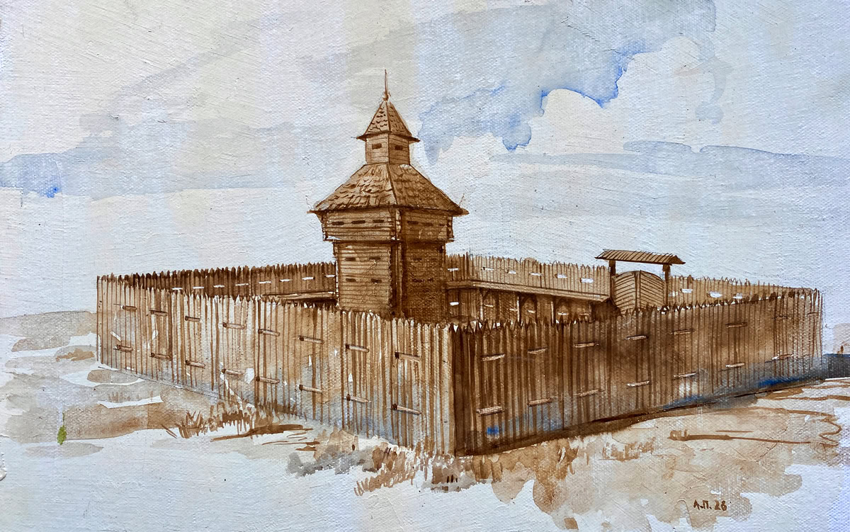
Острожок був побудований при дорозі на Можеський острог. Навкруги нього не було ані ровів, ані валів. Аби його не обійшли зліва чи справа, між лісами була поставлена засіка протягом 200 сажнів (близько 430 м), а до річки Ржавець — надовби у дві кобилини з ланцюгами.
У 1659, 1661 та 1662 роках острожок на Ржавому колодязі відбивався від невеликих татарських загонів, поки не підходила підмога з Харкова. А у 1663 році дорогу з Харкова на Можеський острог перекрила щойно заснована фортеця Мерефа, яка ефективніше могла затримувати противника, якби той вирішив просуватися в бік Харкова. Сторожа на Ржавому колодязі зменшилася вдвічі.
Останній раз повідомлення про сторожу зустрічається у 1666 році, а вже наступного року острожок стояв порожній: «Засека и надолбы опали и огнили во многих местех». В «Сметной книге» 1669 року острожок згадується востаннє: «И в том острожке сторожи нет, потому что от Мурамского шляху поселилась слабода морефа на стороже. Из Харькова нигде ни в которых местех никаких чинов люди не бывают».
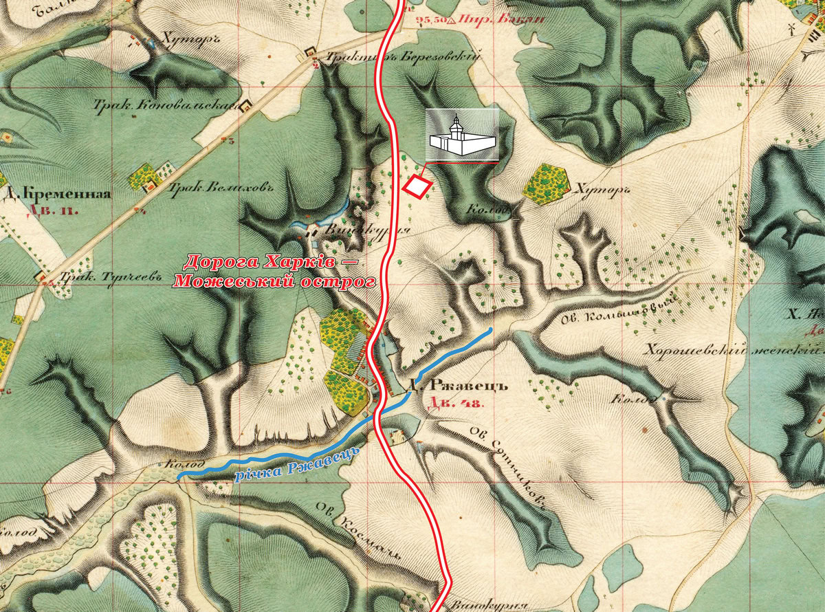
Після того, як харківським полковником у 1669 році став Григорій Єрофійович Донець-Захаржевський, він витіснив зі своїх земель служилих людей, які володіли Бабаями та Жихорем, і почав заселяти їх підданими черкасами, заснувавши нові села. Зокрема значно нижче від острожка, при дорозі на Валки, з’явився хутір Ржавець, який мав тоді назву Саломахівка. Ця назва зберіглася щонайменше до 1782 року. Тоді тут у 27 дворах проживало 166 чоловіків та 169 жінок підданих черкас, які належали Петру Андрійовичу Щербініну, знайомцеві Григорія Сковороди.
А от уже на 1804 рік Саломахівка фігурує в документах як село Ржавець, що стоїть на колишній дорозі на Валки, а тепер — при великій поштовій дорозі на губернське місто Катеринослав (сучасний Дніпро). Тут є будинок для приїзду поміщиці, дружини полковника Андрія Петровича Щербініна, Катерини, а також постоялі двори титулярного радника Миколи Колядіна та прапорщика Григорія Топчієва. У Щербініної при селі було 20 селітряних буртів (на рік з них виварювали до 400 пудів селітри, яка тоді використовувалась у виробництві пороху). Кріпаки були на оброці, сплачували поміщиці по 200 руб. на рік. Вони вважалися заможними, оскільки мали сади, бджолині заводи та рибні ловлі на власному ставку.
У XIX столітті село Ржавець входило до земельної дачі села Березове, а в духовному плані — відносилося до парафії Архангело-Михайлівської церкви села Бабаї. Ржавець почав занепадати після того, як дорога на Катеринослав стала проходити північніше нього, а стара дорога стала другорядною. У 1879 році в селі налічувалося 72 двори, в яких проживали 182 чоловіки та 200 жінок. Єдиним центром суспільного життя був шинок.
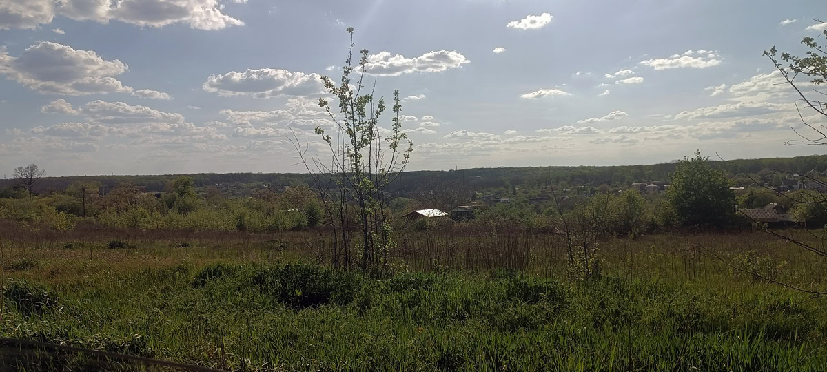
Сьогодні місце, де колись стояв острожок, є закритою територією, недоступною для дослідників, а от в 1,5 км від сучасного села Ржавець, на лівому березі однойменної річки, археологи виявили городище скіфських часів.
«Фортеця Харків» — цикл матеріалів дослідника історії Слобідської України Андрія Парамонова. Читайте колонку автора на MediaPort